
SES adjust 3D TSD Geosteering Software
Maximize confidence and results with advanced 3D geosteering.
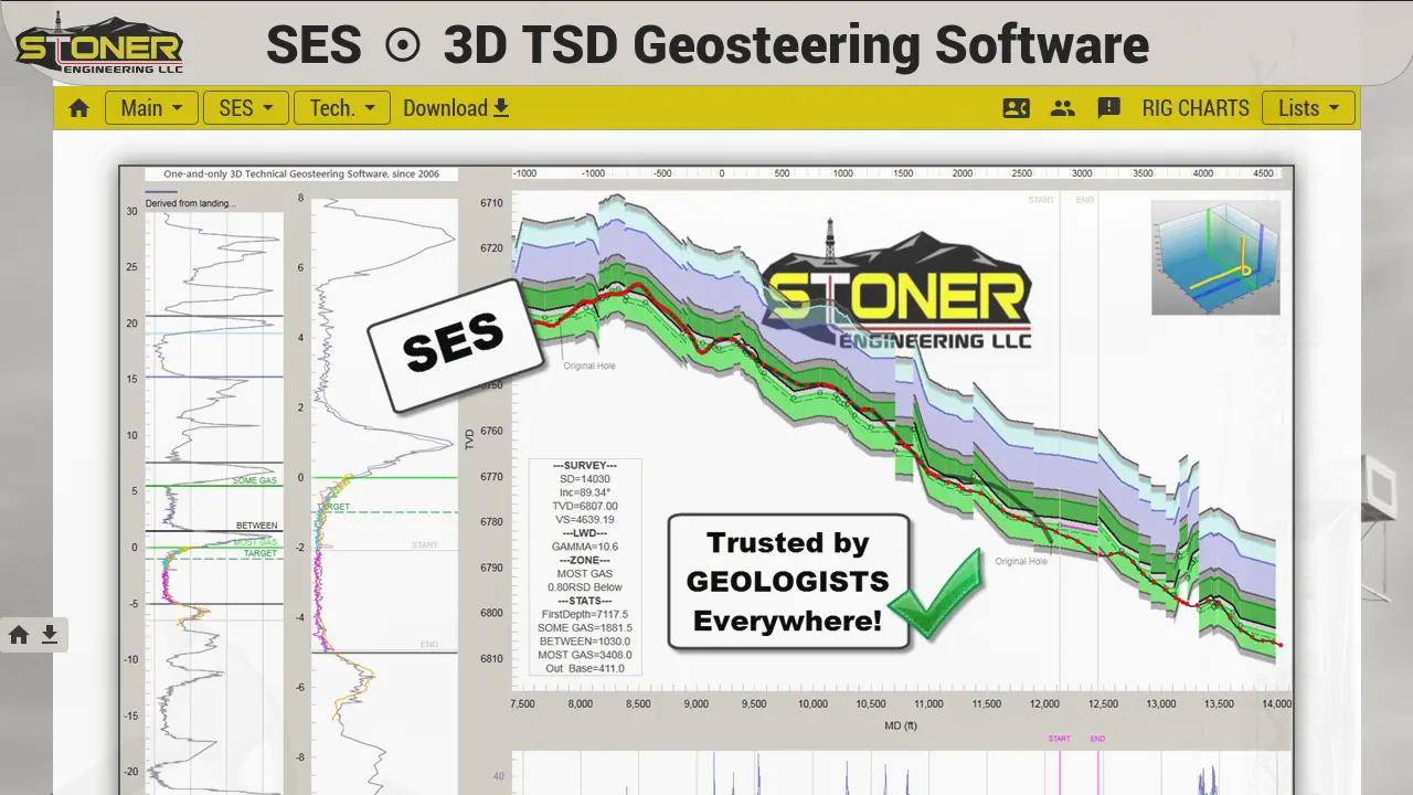
Description
SES adjust 3D TSD Geosteering Software empowers geologists and engineers to interpret and steer wells accurately with its advanced 3D geosteering technology. Developed by Stoner Engineering, SES uses a unique combination of true stratigraphic depth mapping and 3D vector geometry to precisely correlate well log data and capture structural details at the drilling scale.
Trusted by professionals for over 18 years, SES integrates exclusive petroleum engineering principles and real-time analytical tools to enhance decision-making and reservoir development. Its robust functionality supports high-confidence well planning and execution, making it a preferred solution for technical geosteering in modern oil and gas operations.
Key Features
- 3D Geosteering Mechanics: Visualize and analyze wellbore placement in three dimensions
- 3D Tech Hole Deviation: Accurately measures deviation for improved drilling decisions
- 3D GeoSteering Guidance: Real-time 3D guidance for navigating subsurface formations
- 3D DirSteering Guidance: Directional technical support for horizontal wells
- Unique 3D Well Log Correlation: Transforms LWD signals using vector geometry for precise stratigraphic positioning
- Fully-integrated Petroleum Engineering Principles: Incorporates exclusive engineering and geosteering logic
- Industry-hardened Software: Trusted by over 250 companies and thousands of users
- Efficient Data Interpretation: Minimal section blocks needed for reliable interpretation
- Superior to 2D Solutions: Enhanced accuracy compared to traditional 2D well planning tools
- Distinct MD-Domain Cross-Section Analyses: Supports true measured depth domain studies
Use Cases
- High-precision geosteering of horizontal or high-angle wells
- Real-time navigation and steering during drilling operations
- Wellbore structural mapping in complex geology
- Correlation of well log and formation data
- Efficient payzone identification and mapping
- Well planning and design optimization
- Reservoir development and analysis
You Might Also Like

Kendal
Contact for PricingThe AI-Powered Real Estate CRM That Works For You 24/7

GaliChat
FreemiumAI Agents Trained on Your Knowledge Base

Maian Lockbox
FreemiumFree PHP Membership and Subscription System

Talkzy
Free TrialYour AI-based Scrum Master

Conversed.ai
Contact for PricingAI Agents for more revenue, lower costs, happier customers, and a more productive team.